What do you need to navigate in winter?
If you are in nature in winter it is different. Everything is covered with a layer of snow. It smells different, it sounds different and time sometimes seems to stand still.
But while you yourself are not standing still and moving, it is of (life) importance that you know where you are. Navigating is an essential part of winter expeditions.
Navigating is a little different than in summer. (You can read how in the blog: How to stay on course by navigating well) In winter, trails are covered with snow. So everywhere you go, it looks more or less the same. Contours are less obvious. Markings are snowed under. Should they have already been there.
Instead of applying micro-navigation. Where am I on this path? Is it more convenient to apply macro navigation. Where am I in this valley? Look at the larger element around you and determine your position on the map. Do you have to have it with you….
In this article discuss the minimum equipment you should carry for proper navigation in winter.
The equipment to navigate in winter is at least a map and compass. But a GPS is also definitely recommended. Make sure your gear works even in winter, and thus in frost. And that they can be operated with gloves on. Often everything works well in the store and at home, but is just a little more difficult in the field. And that is precisely when it comes down to it. So at home and in the store, you might well test all your gear with gloves on. You will be amazed at how clumsy some things go.

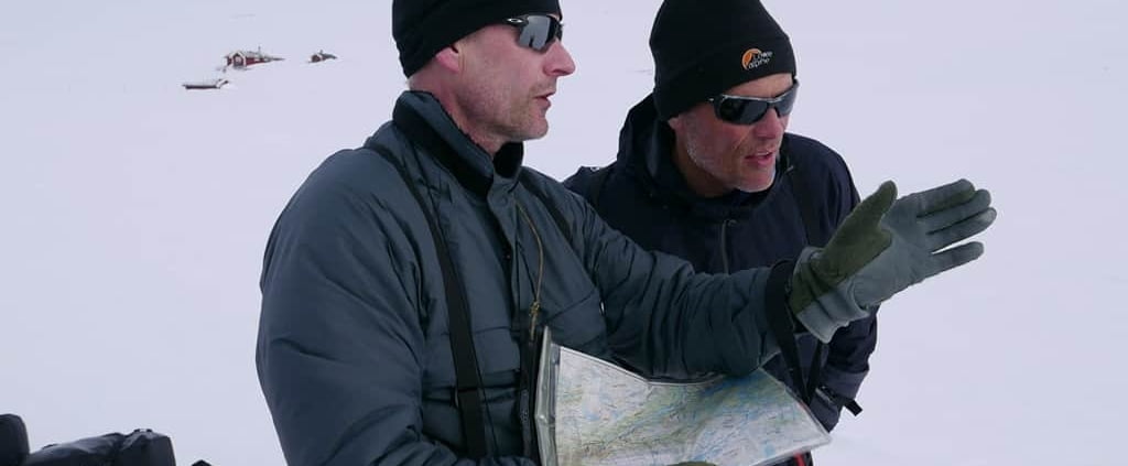
Map study in a cabin in Norway during the Heroes of Telemarken trip
Maps for your orientation.
A 1:100,000 map is fine and will suffice in most cases. But if a 1:50,000 map is available, this is often more convenient. Unless you are going to cross Greenland. Because then you drag a lot of cards that are all more or less white. In that case, you can also navigate with maps of only the beginning and the end of the expedition.
Often a card can be obtained from some kind of plastic. This is convenient because these cards are stronger and can withstand moisture better. So such a card lasts longer.
Just remember to use a recent map. So check the date of issuance and compare the card you have with the one on sale now. Roads, villages, glaciers. They are all subject to change. You can easily buy a good map at card store de Zwerver in Groningen.

Topographic map of Kebnekaisefjällen
Card cover to protect your card.
A card case is handy for storing the card. A card case is ideally made of flexible plastic with silicone in it. This is also good to use in freezing weather. Ortlieb has good card covers that last a long time.
The card case should have a string that allows you to wear the card case over your neck. Then put your arm through the sleeve and string. This prevents infinite rotation of the card cover when it is windy. This prevents you from more or less suffocating as the string twists around your neck, and it also makes it easier to grab the card and hold it in front of you.
While moving, it is convenient to keep the map on your back or under your arm when not in use.
By the way, should you buy a card case where the string has a quick release. Such a closure that prevents you from getting choked. Decathlon’ s card covers, for example, have this. Then remove that fastener and tie a knot in the rope. The last thing you want is for the quick release to come loose in a storm and blow your card away.

Waterproof map case from Ortlieb in A-4 format
Your compass is the second item that is indispensable. Choose a simple compass. Preferably a plate compass. This compass has no external movable parts that can break. Also, you don’t have to unfold or pull this compass first. Thus, this compass is always ready for use. Even with gloves on, this compass is easy to hold in your hand and you have a quick understanding of your course.
Of course, there is a string on the compass. Wear your compass around your neck or attach the string to something else. That way it won’t fall in or perhaps under the snow if you drop it.
I myself work in winter with a compass from Suunto. While crossing Greenland, I used the Suunto A-10. This compass costs less than €20 and is perfect for this expedition.

Suunto A-10 compass with whistle and cabin key
Google maps is definitely on your phone. And so there are plenty of apps that make navigating in nature easy. Think Maps.me, Guru Maps, Outdooractive or the various topographic services that have released an app with their maps.
But … that battery and coverage. In the winter, there are some disadvantages to navigating with your phone. Just to start with the battery. That one doesn’t last very long. Often your phone will continue to do fine when it’s in your pocket or sleeping bag. But as soon as you take it out it starts complaining. With a dead battery in the end.
Also, mobile network coverage is not perfect. So apps that need to use network coverage don’t work or work poorly. In such a case, download in advance the maps of the area you are going to.
And then the ministry. Have you ever tried operating your phone with gloves on? It often doesn’t. So gloves off, operating phone and getting frozen fingers in the meantime. All in all, plenty of reasons not to have to depend 100% on your phone.
But a GPS is handy. If only to check at home on the computer to see where you have all walked now. A GPS tells you exactly where you are. It does that with coordinates. And depending on the GPS also with a map on the screen. Personally, I use the Garmin GPSmap 62s. This is a somewhat older model from Garmin, but it works fine.
The GPS has large buttons and can be operated with gloves on. Okay, sometimes I hit the wrong button. But often it goes well. The GPSmap 62s has a fast “fix. So he quickly knows exactly where you are. And it uses little energy. In the GPS, I put Lithium AA batteries from Energizer. These are lighter than regular AA batteries. And in the cold, they last longer, too. I also provide the GPS with a string. A red one in my case. That stands out nicely.

Garmin GPSMap 62s
Extras to make it easier
A watch, pen and notebook are also handy. Note what time you leave and stop. And note the distance you traveled. This will give you a better understanding of how far you travel in an hour or day.
The watch I wear I simple. It is a digital watch that at least tells the time. It’s on my wrist. So I don’t have to grab the phone or GPS to see the time.

Casio Watch with Altimeter
To take notes, I use a pencil. Always works. Russian cosmonauts knew that, too. So why use anything else? Ink freezes and can sputter. A pencil is light and writes. Does what it needs to do.
I take notes in a notebook from Rite in to Rain. These notebooks, aside from being beautiful yellow, are perfect for outdoors. They can have a rain shower. And so it did snow. Tear hard and are of a manageable size. Perfect for notes, journal or inspiration brain dumps.

Rite in the rain with pencil
Conclusion
Map, compass and GPS. These should go with you in your backpack.
But surely the most important thing is knowledge. This is the basics. What good is your stuff if you don’t know how to use it. Practice at home with all your equipment. If necessary, do a map and compass navigation workshop. Go Geocaching with your GPS. Make the items and their use your own.
The last thing you want is to find yourself in winter not knowing where you are or where to go. Then you want to enjoy nature and navigation is a tool.


Leave a Reply
Want to join the discussion?Feel free to contribute!